Commentary: Redistricting map is a stain on the political process
By Len Lazarick
When Del. Neil Parrott was gathering petition signatures to put congressional redistricting on the ballot so voters could overturn it, he found that all he needed to do was show people the map itself and they were ready to sign on.
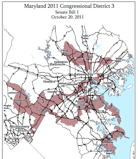
That’s the same appalled reaction I found last week when I made a presentation on Question 5 to students and staff at the University of Maryland Baltimore. All they had to do was look at the map, particularly the lines for the 3rd Congressional District, to realize there was something very wrong.
That map to the right has been called an ink blot, a blood splatter, a rabbit after a blast from a shot gun and, as one federal judge put it, “a Rorschach-like eyesore.” Another federal judge described it as “a broken-winged pterodactyl, lying prostrate across the center of the State.”
“In form, the original Massachusetts Gerrymander looks tame by comparison,” wrote Appellate Judge Paul Niemeyer in his opinion. And so it does, as shown by the 18th century cartoon that gave us the word combining Gov. Elbridge Gerry and his salamander of a congressional district.
Blatantly bogus arguments
While there are legitimate arguments on both sides of the other three ballot questions – expanded gambling, same-sex marriage, tuition breaks for immigrant children – all the arguments for Question 5 are blatantly bogus.
Democrats supporting the maps say they were drawn in an “open and transparent process” and, in the end, that the redistricting itself was fair, bipartisan and approved by the courts. Those adjectives are mostly untrue.
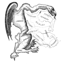
A cartoonist’s view of the gerrymandered “salamander district,” drawn by Massachusetts Gov. Elbridge Gerry in 1812.
On the July 4th weekend last year, Gov. Martin O’Malley appointed the Governor’s Redistricting Advisory Committee. Since he did not create it by executive order and it was advisory to the chief executive, it did not have to abide by the Open Meetings Act.
The five members were the Democratic governor’s own patronage chief as chair, the Democratic president of the Senate, the Democratic Speaker of the House of Delegates, a Democrat who had chaired O’Malley’s reelection bid in Prince George’s County (and has since gone to prison for federal tax evasion), and one Republican, a former one-term delegate selected without consulting GOP officials.
Behind closed doors, and a legislative rush
The committee had a dozen hearings around the state, but never presented its own plan to the public. Ultimately it drew
the congressional map in secret behind closed doors and released it on the Internet with a one-week comment period.
The governor published the final map on a Saturday evening without a public hearing, just two days before the special session of the legislature he had called to approve it.
The bill was introduced the following Monday morning, a joint hearing was held that afternoon, and the Senate redistricting committee approved it immediately after the hearing. It was rammed through the Senate, and passed the next morning.
Alternative plans got little consideration, and the process was so rushed that the bill had to be revised at the last minute to fix drafting errors.
The House of Delegates followed similar quick procedures but a Republican parliamentary maneuver held up it up for a day. It took a little more than 72 hours to have it passed and signed by the governor.
Not a single Republican voted for the plan at any stage of the process: not former Del. Jim King on the advisory committee, none of nine GOP legislators on either committee that reviewed it and none of the 55 Republicans in the House and Senate.
Bartlett targeted for defeat
The map was drawn specifically to make it easier to defeat 10-term incumbent Republican

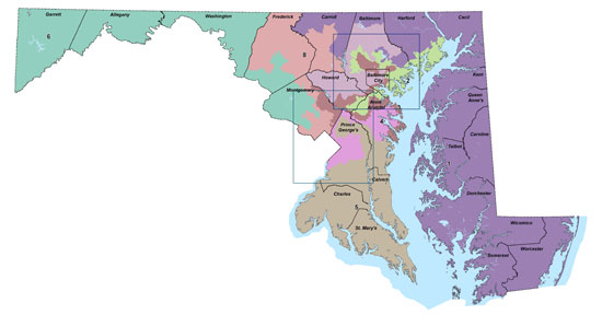
Where congressmen live: A. Andy Harris, B. Dutch Ruppersberger; C. John Sarbanes; D. Elijah Cummings
Roscoe Bartlett in the 6th Congressional District, and it looks like that is what is going to happen. Tens of thousands of reliable Republican voters from Carroll and Frederick counties were taken out of the 6th, and replaced with Democratic voters from Montgomery County.
The Census was established in the U.S. Constitution to apportion fair and equal representation in the U.S. House of Representatives. Every 10 years, redistricting is done to reflect population changes.
As reported in our first story about the “monstrous 3rd district” a year ago, from 2000 to 2010, the population of Maryland grew by about 9%, but six of the eight existing congressional districts were within plus or minus 3% of the ideal size of 721,529 people. Yet, despite the relatively small adjustments needed to reflect growth, the O’Malley redistricting plan moves 30% of the population into different districts.
Screwing Republicans and minorities
Typically, in any statewide race – for president, governor, comptroller, attorney general or U.S. Senate – even a little-known Republican will garner at least 35% of the vote. In the last three elections, eight statewide Republican candidates averaged over 40% of the vote. Yet, in the map Democrats drew, Republicans are designed to have just 12.5% of the members of Congress.
African Americans, Hispanics and Asians are now 45% of the population, but will hold 25% of the congressional seats (20% if you count the Senate). Non-Hispanic white males, now less than 25% of the population, will hold 75% of the seats.
This is why Republicans and African Americans made common cause in a federal lawsuit. The three federal judges who ruled in the case were sympathetic to the arguments, but felt their hands were tied by the failure of the Supreme Court to give them clear guidance in rejecting partisan gerrymandering.
 Divided communities, lack of common interests
Judge Niemeyer from the 4th Circuit Court of Appeals saw some of the obvious problems:
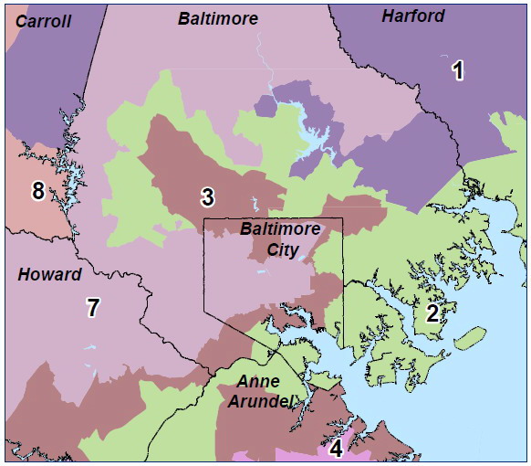
“Admittedly, the shapes of several of the districts in the State Plan are unusually odd. Many obvious communities of interest are divided. For instance, Baltimore City, which could be placed in one congressional district given its current population, is instead split between three. Other districts combine citizens with widely divergent interests. That a farmer in Oakland should share a Representative with a federal contractor living in Potomac is, we think, a suspect proposition.”
Under the current plan, some of the incumbents got to pick their constituents, rather than the constituents picking their representatives. It is most obvious in the Baltimore area, where half of the state’s eight members of Congress live within a 10-mile radius of Towson (see map at right) – and the two U.S. Senators almost fit into that circle as well.
In a concurring opinion, Judge Roger Titus wrote: “It is clear that the plan adopted by the General Assembly of Maryland is, by any reasonable standard, a blatant political gerrymander. If the claim had been pressed by the plaintiffs and an acceptable standard existed for judging it, I would not have hesitated to strike down the Maryland plan.”
Ex-Supreme Court justice: “outrageously unconstitutional”
So much for the court “approving” the plan. The Supreme Court refused to review the decision on appeal – given that it has declined to come up with clear standards for illegal gerrymandering. One retired Supreme Court justice did call the new Maryland plan “outrageously unconstitutional.”
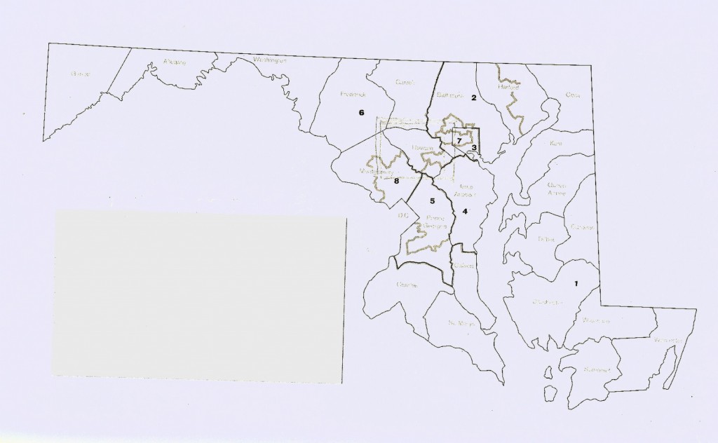
Admittedly, Maryland has an unusual shape exacerbated by the Chesapeake Bay and the Potomac River, its long border with Virginia and West Virginia. But 30 years ago, the eight congressional districts were much more compact, as seen in the map to the right. Anne Arundel County was in a single district with its own resident congresswoman, the state’s only Republican representative at the time. Three of the other representatives were what used to be called “conservative” Democrats – Beverly Byron, Roy Dyson and Clarence Long. Now conservative Democrats are long gone.
Maryland now has the distinction of having the most gerrymandered, least compact congressional districts in the nation based on mathematic modeling. That’s quite a feat given that Maryland was competing against 49 other states and their 427 districts.
Rejecting the map is unlikely
Overturning the current plan will be hard, as was getting the petition signatures to put it on the ballot. Only 30% of the voters have switched districts, and only in the 6th District will they change representatives. There is no money in this fight, and only a few Democratic politicos from Montgomery County are openly opposing the map. Even if voters reject the current map, the same governor and legislators will be in charge of drawing a new one.
There is some slim chance imaginable that an embarrassed governor and Democratic Party leaders would agree to an independent, non-partisan commission to draw the lines, as now happens in eight states. But Maryland’s Democratic pols drew the new map in such a partisan way because they were able to – as Republican pols in many other states have done. The temptation to manipulate the lines for partisan power might overcome any temporary embarrassment if by some miracle voters reject Question 5 and its bland language.
Background from previous stories
Here are some previous stories that provide additional background.
http://marylandreporter.com/2011/10/12/bolstering-representation-helps-all-minorities-including-gop/
http://marylandreporter.com/2011/10/05/analysis-30-solution-creates-monstrous-3rd-district/
http://marylandreporter.com/2011/10/18/omalley-redistricting-plan-passes-senate-goes-to-house/
http://marylandreporter.com/2011/10/12/minority-leaders-denounce-proposed-redistricting-maps/
http://www.hocorising.com/2012/10/question-5-marylands-shameful.html
For more stories, go to the menu at the top of this page, and click on “Hot Topics” “Redistricting.”

MarylandReporter.com is a daily news website produced by journalists committed to making state government as open, transparent, accountable and responsive as possible – in deed, not just in promise. We believe the people who pay for this government are entitled to have their money spent in an efficient and effective way, and that they are entitled to keep as much of their hard-earned dollars as they possibly can.

